What's new
Christian Community Forum

Register a free account today to become a member! Once signed in, you'll be able to participate on this site by adding your own topics and posts, as well as connect with other members through your own private inbox!

MERGED: Hurricane Milton reports and reactions!

Tropical Storm Milton has formed in the Gulf of Mexico and is forecast to strengthen into a hurricane headed toward Florida with possible impacts to its western coast, the National Hurricane Center said on Saturday. Maximum sustained winds are expected to be at 40 mph with higher gusts and Milton is currently moving north-northeast, NHC said in an advisory.

Milton is forecast to undergo a period of rapid intensification before it makes landfall as a Category 2 hurricane across Florida's west coast, CBS News Miami reported.

The forecast comes a little more than a week after Hurricane Helene made landfall in Florida and across the Southeast, killing more than 200 people and causing immense destruction. President Biden on Thursday took an aerial tour of Florida's Big Bend where Helene struck as a Category 4 storm. Hundreds of people are still missing and Mr. Biden said the work to rebuild will cost "billions of dollars" as communities suffer still without power, running water and passable roads.

More

 
This is a Cat 5 but Thank the Lord, THANK YOU LORD there is a downward air system that they say will weaken this thing right before it hits. It is supposed to hit the Tampa area as a Cat 3. I am on the North-ish, Central part of the peninsula. Concerns will be loss of power, tornadoes and trees coming down. Many large oak trees in this area.
I'm praying for you and everyone in the path of this storm 🙏 🙏🙏
 
The interstates are clogged up with people evacuating the coasts. Gas lines are long. The stores are getting iffy. Thankfully we went and got bottled water on Sunday to top off our big emergency water storage which is in jars. Plenty of food - right as this thing hits we are going to put frozen ice packs and frozen waters into a cooler and put some milk in there, cheese, eggs etc…that way when the power goes out we won’t have to open our refrigerator or freezer for food. In the past with a 3 day outage we have gotten away with minimal food loss doing that. Have our grill to make coffee and cook a little. Have lights that we will charge right before as well as a couple of battery operated little lights. Candles. Hand crank radio. Filled our gas tanks. Have our meds and everything else we need. Went to my Mom’s and got her 500 items off her patio. She wants to ride it out with her cats but I told her only if it’s a 3. If it goes above that she will be coming here. Her house is frame and ours is concrete block.
@Andiamo-- I hope you're right, Andi. I just watched footage of some concrete block houses that had been destroyed in North Carolina last week by Helene.
 
@Andiamo-- I hope you're right, Andi. I just watched footage of some concrete block houses that had been destroyed in North Carolina last week by Helene.
I saw that too and it was shocking. From what I understand those were near rivers and what knocked them out was the tremendous force of the floodwaters - not the wind. We had a cat 3 pass right over us many years ago with many trees downed on our street. The roof would have to blow completely off and the windows would have to blow in for this house to come down. It would have to be a massive Cat 5 or maybe an Oklahoma tornado if it hit us directly. If it’s higher than 3 we will do our best to board up some of the windows.
 
@Andiamo-- I hope you're right, Andi. I just watched footage of some concrete block houses that had been destroyed in North Carolina last week by Helene.
We were on the ground 48 hours after Katrina landed. Part of our area was the ninth ward in New Orleans. Total devastation mainly due to the levee bursting from lake Pontchartrain. There were house ripped completely off their foundation, and a few were a few plots over from where they were. Fast moving water made that whole area look like a small nuke went off. Boats in trees, cars on roofs…etc.
 
We were on the ground 48 hours after Katrina landed. Part of our area was the ninth ward in New Orleans. Total devastation mainly due to the levee bursting from lake Pontchartrain. There were house ripped completely off their foundation, and a few were a few plots over from where they were. Fast moving water made that whole area look like a small nuke went off. Boats in trees, cars on roofs…etc.
That must have been a sight to see in person. God bless you for your service. Yes water is so incredibly powerful. And the pressure is on the ground moving the soils and pushing the houses right off their foundations. I am so glad we don’t live near a river. That would be nerve racking for sure. Also the force of floodwaters is constant.
With a hurricane you have “bands” of wind with a break between them. (Almost an eerie stillness, because you know more is coming! It’s especially strange If the “eye”passes over you. The sun actually comes out!)
If things get bad enough we will stay in our hallway.
 
**Update


Hurricane Milton Discussion Number 12
NWS National Hurricane Center Miami FL AL142024
1000 PM CDT Mon Oct 07 2024

Both Air Force and NOAA Hurricane Hunter aircraft have been
investigating Milton. Earlier, the Hurricane Hunters found that the
minimum central pressure in the eye had dropped to an estimated 897
mb. Based on this, Milton had the fifth lowest central pressure in
the Atlantic basin hurricane record. Subsequent center penetrations
by the aircraft indicated somewhat higher central pressures. Also,
flight-level and dropsonde data from the aircraft suggested some
decrease in intensity, and the advisory intensity is set to 145 kt.
The decrease is likely the result of an eyewall replacement reported
by the Hurricane Hunters, leading to a double wind maximum radially
from the center. Notwithstanding, Milton still remains an extremely
dangerous Category 5 hurricane.

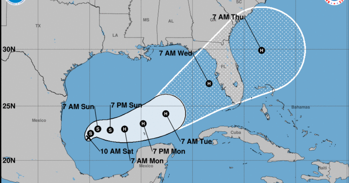
The initial motion is eastward, or 090/8 kt. Milton should continue
to pass close to the northern coast of the Yucatan Peninsula tonight
and early Tuesday. Then, the flow on the eastern side of a
mid-tropospheric shortwave trough dropping into the northwestern
Gulf of Mexico should cause Milton to move east-northeastward to
northeastward at a faster forward speed later on Tuesday and
Wednesday. This motion should take the system across the Florida
peninsula on Thursday. Later in the forecast period, Milton is
expected to move east-northeastward to eastward over the Atlantic
waters off the southeast U.S. coast while gradually losing tropical
characteristics. The official track forecast is close to, but a
little faster than, the model consensus. This is also very similar
to the previous NHC forecast. As noted earlier, the track is closer
to the model predicted fields rather than the model trackers which
appear to be too far south.

So long as Milton remains in an environment of light shear and over
very high oceanic heat content, its maximum intensity should be
governed more by inner-core fluctuations. However the SHIPS
diagnostics indicate a significant increase in vertical wind shear
within 24 hours, likely associated with increasing southwesterly
upper-level flow over the eastern Gulf of Mexico. Therefore a
decrease in intensity is predicted before Milton reaches the western
coast of the Florida Peninsula. Regardless of the peak intensity,
the eyewall replacement cycle will likely lead to an expansion of
the destructive inner core of the hurricane during the next day or
two. The system is expected to be a large and powerful hurricane at
landfall in Florida, with life-threatening hazards at the coastline
and well inland. Residents in Florida should closely follow the
orders from their local emergency management officials, as Milton
has the potential to be one of the most destructive hurricanes on
record for west-central Florida.


Key Messages:

1. Damaging hurricane-force winds and a life-threatening storm surge
with destructive waves are expected across portions of the northern
coast of the Yucatan Peninsula through tonight.

2. Milton is expected to grow in size and remain an extremely
dangerous hurricane when it approaches the west coast of Florida on
Wednesday. A large area of destructive storm surge will occur along
parts of the west coast of Florida on Wednesday. This is an
extremely life-threatening situation and residents in those areas
should follow advice given by local officials and evacuate
immediately if told to do so.

3. Potentially devastating hurricane-force winds are expected along
portions of the west coast of Florida where a Hurricane Warning is
in effect. Milton is forecast to remain a hurricane as it crosses
the Florida Peninsula and life-threatening hurricane-force winds,
especially in gusts, are expected to spread inland across a portion
of the entire Florida Peninsula. Preparations to protect life and
property in the warning areas should be complete by Tuesday night
since tropical storm conditions are expected to begin within this
area early Wednesday.

4. Areas of heavy rainfall will continue to impact portions of
Florida well ahead of Milton, with heavy rainfall more directly
related to the system expected Tuesday night through early Thursday.
This rainfall brings the risk of considerable flash, urban, and
areal flooding, along with moderate to major river flooding.
Flooding will be exacerbated in areas where coastal and inland
flooding combine to increase the overall threat.

 
A little history.

Only 40 hurricanes ever have reached CAT-5 which is winds in excess of 157mph. Out of those 40, only 4 ever made landfall while still at CAT-5.

Hurricane Milton is now CAT-5
I was in Miami scuba diving with friends the week before my namesake Hurricane Andrew hit. Our last few dives were canceled because the seas were already too rough four days prior to landfall.

A coworker and I took a truck loaded with supplies to our agency in Miami. We left around 5 pm and arrived in Miami at about 3 am. It took us over a hour and a half to get from the highway a couple of miles to our site.

When the sun came up it looked like a nuclear bomb had went off, most everything was blown flat. There were winds in excess of 200 mph clocked down the high voltage power line right of way adjacent to our facility. There were wild animals from the zoo running through the neighborhood.

The National Guard was flying helicopters around surveying damage and rescuing people.
 
TAMPA – Forecasters say Hurricane Milton has the potential to become one of the most destructive hurricanes on record for west-central Florida, which includes the Tampa area, as millions of residents are in the final hours of preparation.

"It’s worth emphasizing that this is a very serious situation," the National Hurricane Center warned on Tuesday. "Milton has the potential to be one of the most destructive hurricanes on record for west-central Florida."

More

 
I was in Miami scuba diving with friends the week before my namesake Hurricane Andrew hit. Our last few dives were canceled because the seas were already too rough four days prior to landfall.

A coworker and I took a truck loaded with supplies to our agency in Miami. We left around 5 pm and arrived in Miami at about 3 am. It took us over a hour and a half to get from the highway a couple of miles to our site.

When the sun came up it looked like a nuclear bomb had went off, most everything was blown flat. There were winds in excess of 200 mph clocked down the high voltage power line right of way adjacent to our facility. There were wild animals from the zoo running through the neighborhood.

The National Guard was flying helicopters around surveying damage and rescuing people.
Wow. Andrew was a monster. Swallowed up the whole state. I wasn’t here for that.
 
Parents used to snowbird in Sarasota.
Glad they're not there anymore.


:pray:
:pray:
:amen:
:amen:
:thankyou:
:thankyou:
 
Back
Top