What's new
Christian Community Forum

Register a free account today to become a member! Once signed in, you'll be able to participate on this site by adding your own topics and posts, as well as connect with other members through your own private inbox!

MERGED: Hurricane Milton reports and reactions!

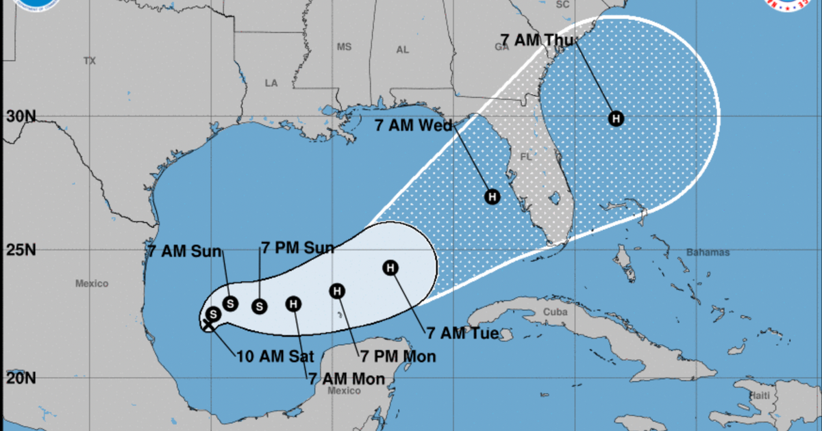
Tropical Storm Milton has formed in the Gulf of Mexico and is forecast to strengthen into a hurricane headed toward Florida with possible impacts to its western coast, the National Hurricane Center said on Saturday. Maximum sustained winds are expected to be at 40 mph with higher gusts and Milton is currently moving north-northeast, NHC said in an advisory.

Milton is forecast to undergo a period of rapid intensification before it makes landfall as a Category 2 hurricane across Florida's west coast, CBS News Miami reported.

The forecast comes a little more than a week after Hurricane Helene made landfall in Florida and across the Southeast, killing more than 200 people and causing immense destruction. President Biden on Thursday took an aerial tour of Florida's Big Bend where Helene struck as a Category 4 storm. Hundreds of people are still missing and Mr. Biden said the work to rebuild will cost "billions of dollars" as communities suffer still without power, running water and passable roads.

More

 
Milton expected to become a major hurricane before slamming into Florida
MIAMI — An alarming change in the forecast now shows the potential for a dangerous hurricane to strike the west coast of Florida during the workweek with damaging winds, life-threatening storm surge and torrential rain.

The budding cyclone was designated Tropical Storm Milton on Saturday afternoon by the National Hurricane Center, but it's now expected to rapidly intensify into a hurricane by Monday and reach Florida on Wednesday.

The forecast with Milton has evolved quite a bit in the last 24 hours, showing greater potential to be a more significant storm.

"I don't like the way this is developing at all, and it's going to happen pretty quickly," says FOX Weather Hurricane Specialist Bryan Norcross. "It just means the odds are significantly higher (Saturday) than they were (Friday) that a memorable, impactful storm is going to impact Florida in the days ahead."

The National Hurricane Center is now forecasting Hurricane Milton to make landfall around the Tampa metro as a Category 3 hurricane.

More

Lord please weaken the strength of this storm and may Your Mercy and Shield be over everyone in the vicinity of where it may fall in Jesus name 🙏
 

**Update​

Sunday updates: School closures, evacuations ordered as Milton picks up steam​


Milton rapidly intensified into a hurricane Sunday and was expected to hit Florida as a “life-threatening” Category 4 storm on Wednesday.

While the storm’s track and intensity were still coming into focus, officials were warning Tampa Bay residents to prepare for the worst-case scenario. The region, still cleaning up from Hurricane Helene, could see up to 12 inches of rain through next week.

Fifty-one Florida counties are under a state of emergency, including Hillsborough, Pinellas and Pasco. The three bay area school districts also closed schools through Wednesday. Pasco has issued mandatory evacuation orders for zones A and B starting Monday.

More

 
**National Hurricane Center Advisory:

The hurricane is still moving east-southeastward, now about 8 kt.
Global models continue to insist that Milton will turn eastward
soon as the frontal low pressure area over the northeastern Gulf of
Mexico departs. The new forecast near Mexico is about the same as
the previous one, but is close enough to bring hurricane-force
winds to the northern portion of Yucatan Peninsula. Later, a new
mid-level trough dropping into the northwestern Gulf of Mexico
should then cause Milton to move east-northeastward to northeastward
at a faster forward speed. The latest model fields are a bit left
of the previous runs, and the official NHC track forecast is shifted
to the north. This forecast is close to a consensus of the latest
GFS, ECMWF and regional hurricane models. Note that this track is
closer to the model fields rather than the model trackers which
appear to be too far south.

Milton is likely to become a category 5 hurricane later today
with light shear and very warm waters in its path. By tomorrow,
its intensity should be dictated by any eyewall replacement
cycles, which will likely cause the system to gradually weaken
but grow larger. After 36 h, Milton is expected to encounter a
much less favorable environment with strong shear and dry air
entrainment. Therefore, some weakening is anticipated before the
hurricane reaches the Florida Gulf coast. However, the system is
still likely to be a large and powerful hurricane at landfall in
Florida, with life-threatening hazards at the coastline and well
inland. After landfall, Milton should weaken and start extratropical
transition, which should be complete by 96 h.

Key Messages:

1. Damaging hurricane-force winds are expected across portions of
the northern coast of the Yucatan Peninsula. A life-threatening
storm surge with damaging waves is also likely along portions of
the northern coast of the Yucatan Peninsula.

2. There is an increasing risk of life-threatening storm surge and
damaging winds for portions of the west coast of the Florida
Peninsula beginning Tuesday night or early Wednesday. Storm Surge
and Hurricane Watches are now in effect for portions of the west
coast of the Florida Peninsula and residents in that area should
follow any advice given by local officials and evacuate if told to
do so.

3. Areas of heavy rainfall will impact portions of Florida today
well ahead of Milton, with heavy rainfall more directly related to
the system expected later on Tuesday through Wednesday night. This
rainfall will bring the risk of considerable flash, urban, and
areal flooding, along with the potentia
l for moderate to major
river flooding.

🙏🙏🙏🙏
 
This is a Cat 5 but Thank the Lord, THANK YOU LORD there is a downward air system that they say will weaken this thing right before it hits. It is supposed to hit the Tampa area as a Cat 3. I am on the North-ish, Central part of the peninsula. Concerns will be loss of power, tornadoes and trees coming down. Many large oak trees in this area.
 
The interstates are clogged up with people evacuating the coasts. Gas lines are long. The stores are getting iffy. Thankfully we went and got bottled water on Sunday to top off our big emergency water storage which is in jars. Plenty of food - right as this thing hits we are going to put frozen ice packs and frozen waters into a cooler and put some milk in there, cheese, eggs etc…that way when the power goes out we won’t have to open our refrigerator or freezer for food. In the past with a 3 day outage we have gotten away with minimal food loss doing that. Have our grill to make coffee and cook a little. Have lights that we will charge right before as well as a couple of battery operated little lights. Candles. Hand crank radio. Filled our gas tanks. Have our meds and everything else we need. Went to my Mom’s and got her 500 items off her patio. She wants to ride it out with her cats but I told her only if it’s a 3. If it goes above that she will be coming here. Her house is frame and ours is concrete block.
 
The interstates are clogged up with people evacuating the coasts. Gas lines are long. The stores are getting iffy. Thankfully we went and got bottled water on Sunday to top off our big emergency water storage which is in jars. Plenty of food - right as this thing hits we are going to put frozen ice packs and frozen waters into a cooler and put some milk in there, cheese, eggs etc…that way when the power goes out we won’t have to open our refrigerator or freezer for food. In the past with a 3 day outage we have gotten away with minimal food loss doing that. Have our grill to make coffee and cook a little. Have lights that we will charge right before as well as a couple of battery operated little lights. Candles. Hand crank radio. Filled our gas tanks. Have our meds and everything else we need. Went to my Mom’s and got her 500 items off her patio. She wants to ride it out with her cats but I told her only if it’s a 3. If it goes above that she will be coming here. Her house is frame and ours is concrete block.
Andrea's and my prayers are with y'all. :pray: :pray: And with everyone else here in this storm's path.
 
The interstates are clogged up with people evacuating the coasts. Gas lines are long. The stores are getting iffy. Thankfully we went and got bottled water on Sunday to top off our big emergency water storage which is in jars. Plenty of food - right as this thing hits we are going to put frozen ice packs and frozen waters into a cooler and put some milk in there, cheese, eggs etc…that way when the power goes out we won’t have to open our refrigerator or freezer for food. In the past with a 3 day outage we have gotten away with minimal food loss doing that. Have our grill to make coffee and cook a little. Have lights that we will charge right before as well as a couple of battery operated little lights. Candles. Hand crank radio. Filled our gas tanks. Have our meds and everything else we need. Went to my Mom’s and got her 500 items off her patio. She wants to ride it out with her cats but I told her only if it’s a 3. If it goes above that she will be coming here. Her house is frame and ours is concrete block.
Our house is in prayer for you and Nails.
 
Back
Top